Rangeland
Rangeland — NIR2,126 points · 4000–12500 cm⁻¹
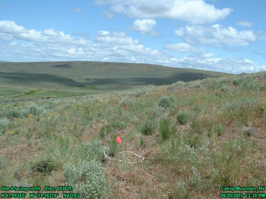
Sample photograph — USGS Spectral Library v7
Spectrum Details
- Modality
- NIR
- Category
- vegetation
- Material Type
- PLANT
- Sample ID
- C03-004
- Collection Locality
- Catnip Mountain, in the Sheldon-Hart Mountain National Wildlife Refuge Complex, is located in northwestern Nevada, approximately 55 miles southeast of Lakeview, Oregon
- Spectral Purity
- 1a2_3_4_ # 1= 0.2-3, 2= 1.5-6, 3= 6-25, 4= 20-150 microns
- Sample Description
- This spectrum is the average reflectance for an area of rangeland covered by mixed shrubs, grasses and forbs as detailed in this description of site number C03-004. Collection Date The reflectance data were collected on 20-Jun-2003. Site Vegetation Description The total vegetation cover on this site was 52%. The following table shows the percent cover by cover class: Cover Category, Sub-Category Cover (%) _____________________________ ____________________________ Vegetation, Total Cover 52 Vegetation, Tree 0 Vegetation, Shrub 8 Vegetation, Grass 27 Vegetation, Forb 17 Non-vegetation, Total Cover 48 Non-vegetation, Litter 11 Non-vegetation, Bare 37 Non-vegetation, Other 0 _____________________________ ____________________________ The following table shows the cover by shrub species in the site (for shrubs with greater than 2% cover): Shrub Species Cover (%) Avg. Height (cm) _____________________________________ ____________ __________________ Tetradymia canescens 5 29 Chrysothamnus viscidiflorus 2 23 _____________________________________ ____________ __________________ The following table shows the cover by grass species in the site (for grasses with greater than 2% cover): Grass Species Cover (%) _____________________________________ _____________ Poa secunda 10 Bromus tectorum 7 Festuca idahoensis 5 Elymus elymoides 4 _____________________________________ _____________ The following table shows the cover by forb species in the site (for forbs with greater than 2% cover): Forb Species Cover (%) _____________________________________ _____________ Lupinus argenteus 8 Collomia linearis 7 _____________________________________ _____________ Field Observations Soil is gravelly. Site Orientation The mean elevation of the site is 1990 m (6529 ft). The mean slope of the site is 20%, with a Northwest aspect of 293 degrees. Site Burn History The site has burned since 1996. Site Location, Dimensions, and Vegetation Sampling The center coordinates of this rangeland plot are 41 deg. 53.605 min. N, 119 deg. 21.730 min. W (datum is NAD83). The diameter of this circular vegetation plot was 15.2 meters. Within this plot, four subplots of 0.5 meter diameter were established 5 meters from the center at the four cardinal directions (north, east, south and west). Within these subplots, grass and forb species were identified and associated percent cover of each were visually estimated. Litter cover and the percent area of bare ground were also visually estimated. For each shrub in the larger plot, the species was identified, the lateral dimensions were measured, and the height was measured. The cover of trees, shrubs, grasses, forbs, litter and bare ground were calculated from the full plot and subplot measurements. Field identifications of Tetradymia canescens (winterfat) were inconsistent between the 2003 and 2004 field seasons. In 2003, some shrubs were identified as Chrysothamnus nauseosus (gray rabbitbrush) and Krascheninnikovia lanata (winterfat). Later, it was determined that some of these shrubs were incorrectly identified and it was decided to label them all as Tetradymia canescens. Spectral Measurement Procedures This spectrum is the average of 36 measurements made throughout site C03-004. These spectra were collected using an ASD Full Range Field Pro spectrometer in reflectance mode, relative to a Spectralon reference panel. While walking through the site, the fiber optic cable was pointed at nadir (straight down) at approximately shoulder height. The instrument was programmed to record 6 second averages of reflectance while moving through the site (thus, each recorded spectrum was an average of 60 individual measurements). These recorded spectra were examined for artifacts due to low signal:noise, detector offsets and atmospheric contamination. Those spectra with large artifacts were not included in further processing. An average of the remaining 36 spectra was computed. This average spectrum was converted to absolute reflectance by multiplying by the reflectance spectrum of the Spectralon reference panel. The following channels were deleted (set to a value of -1.23e+34) from the spectrum because of remaining artifacts: 1-6, 410-413, 576-592, 761-801, 1006-1051, 1441-1591, 2111-2151 (corresponding to the wavelength ranges of 0.350-0.355, 0.759-0.762, 0.925-0.941, 1.110-1.150, 1.355-1.400, 1.790-1.940, and 2.460-2.510 microns). Catnip Mountain General Description The Catnip Mountain study area is located in northwestern Nevada, 55 miles southeast of Lakeview, Oregon, in the "Sheldon-Hart Mountain National Wildlife Refuge Complex," which is managed by the U.S. Fish and Wildlife Service. The approximate center of the study area is 41.8584 degrees North latitude and 119.3533 degrees West longitude. The vegetation cover of the study site consists of areas of decadent or dead bitterbrush (Purshia tridentata) stands with islands of old mountain mahogany (Cercocarpus ledifolius) scattered near the ridges. Mountain big sagebrush (Artemisia tridentata) dominates the low elevation areas with grasses and forbs mixed with mountain big sagebrush. Little sagebrush (Artemisia arbuscula) dominates the cover of the ridges. Elevations of the site are about 6,000 to 7,000 feet (1,830 to 2,135 m). Project Background This site was measured as part of a cooperative U.S. Geological Survey and Bureau of Land Management project funded by the Joint Fire Science Program. IMAGE_OF_SAMPLE:
- X Units
- cm⁻¹
- Y Units
- Absorbance
- Data Points
- 2,126
Download
Attribution
USGS Spectral Library Version 7, U.S. Geological Survey
License: Public Domain
DOI: 10.3133/ds1035Analyze in Workbench
Open this spectrum in the SpectralBench workbench for advanced analysis, peak detection, and comparison.
Open Workbench